You can now access Shortlists through a myJet2 account. So, as well as being able to save, share and compare holidays, you'll also benefit from…
- Save and share shortlists
- Exclusive discounts
- Tailored holidays inspiration
Already a member? Log in

Call to book from 8:30am-8:30pm
Speak to one of our travel experts in our UK Call Centre:
Mon-Fri 8:30am-8.30pm
Saturday & Sunday 8:30am-7:30pm
Please only call a number listed on our website or you can find a travel agent near you.


Yaiza, Lanzarote
Our rating

Based on 134 reviews
7.9 Km to Timanfaya National Park

Yaiza, Lanzarote
Our rating
Based on 250 reviews
8.7 Km to Timanfaya National Park

Tias, Lanzarote

12.0 Km to Timanfaya National Park
Lanzarote
6.1 Km to Timanfaya National Park - Map

Yaiza, Lanzarote
6.1 Km to Timanfaya National Park - Map
Lanzarote
8.6 Km to Timanfaya National Park - Map
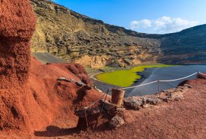
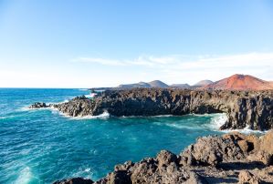
Timanfaya is a national park located on the island of Lanzarote in the Canary Islands, Spain. It's famous for its unique volcanic landscape, created by dramatic eruptions that occurred in the 18th and 19th centuries. It's often referred to as the 'Montañas del Fuego' (Mountains of Fire).
The park is situated in the southwestern part of Lanzarote, primarily within the municipality of Yaiza. The main visitor access point is located near the village of Yaiza.
The landscape was primarily formed by massive volcanic eruptions that lasted from 1730 to 1736, and again briefly in 1824. These eruptions covered a large area with lava flows and volcanic ash, leaving behind a rugged, barren, and incredibly colourful terrain that resembles the surface of Mars.
Allow at least 2 to 3 hours for the main visit, including driving to the centre, waiting for the bus, the bus tour itself (approx. 30-40 mins), seeing the geothermal demos, and potentially visiting the restaurant or gift shop. If you do the camel ride as well, add extra time.
We don’t have any villas in this resort right now. But we’ve hundreds available in other destinations, so find your perfect one now.